Google Maps for Android now includes transit navigation for 400+ cities

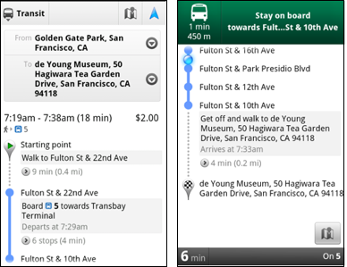
Google continues to plug in public transportation information with a new update for its Maps for Android app that includes stop-by-stop transit navigation.
Although it's still in beta mode, Google Maps for Android already has over 12 billion miles of GPS-guided driving and walking directions on board. Now, with Google Maps 5.7, Android smartphone owners will also be able to access public transit directions in more than 400 cities worldwide. (See the full list here.)
Essentially, the app utilizes the smartphone's GPS function to determine the user's current location along a particular route. Once the user inputs the destination, then the app will publish alerts about possible transfers and when to disembark.
Obviously, one of the drawbacks could be reception interference. To be able to fully take advantage of this new feature, users will likely have to be above ground.
Nevertheless, this function could prove invaluable to travelers when visiting cities with different languages and alphabets on signs that the user might not understand. (Of course, they just can't forget about that international data plan first...)
Google Maps for Android as well as mobile and desktop browsers was recently updated in June with live public transit information about real-time and scheduled departure times, route maps and service alerts.
Some of the other enhancements in this version of Google Maps include an updated directions interface, improved search suggestions (with Google Places integrated), and a photo viewer for Place pages.
Available for downloading now, Google Maps 5.7 requires Android 2.1 and higher. For a closer look at the new features, check out the promo video below:
Related:
