NASA paints Google Earth with near real-time information

NASA is now providing some interesting KML files that add near real-time overlays to Google Earth. The information they are using comes from MODIS (Moderate-resolution Imaging Spectroradiometer) -- some data from this source (updated daily) can be viewed on Google Earth by clicking here.
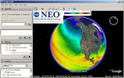
One example of the new data is temperature maps [KML]. This overlay shows a graphically pleasing representation of temperature for large bodies of water around the globe -- the colors remind me of Google Mars.
In addition to sea temperatures, NASA is also now providing near real-time information for global chlorophyll levels, cloud fraction and snow cover.
Even though I probably will not use this information in real life, this information about sea temperature, chlorophyll levels, cloud fraction and snow cover is now only a click away -- it's scary to think how much information we "know" actually lives on the internet, or at least in databases other than our brain.
[via Google Earth Blog]