Tracking Campaign Signs with Google

Bryan Catherman has written at UtahPolitics.org about Pete Ashdown's mashup for tracking the location of campaign signs.
Ashdown, who is running against incumbent Senator Orrin Hatch (UT), has developed an interactive map indicating the location of his campaign signs. But it doesn't stop there---sign owners may take a photo of their sign and post it on the map. Because of possible sign theft, Ashdown has challenged sign owners to catch would-be-thieves in the act. There's even a reward. Even now, there are likely scores of other computer nerds setting up motion detection, night-vision webcams.
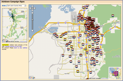
One unintended consequence of this kind of political mashup is that it could be used to infer (correctly or incorrectly) support and where it's concentrated. For example, looking at this map, one would conclude that Pete has almost no support outside of the east side of Salt Lake City, the most Democratic area of the entire state.
On the other hand, this represents an opportunity for Ashdown supporters in other areas to get out and get their signs online. By showing an increase in the number of signs in more Republican areas of the state, Ashdown could show growing support and turn that into real momentum.
The possibilities for doing things like this in the political arena are huge. Campaigns are naturally based on geography. For example, how could something like this be used to form groups of supporters in neighborhoods and organize the campaign? With a little more support (hooks to Meet-Up, etc.) this could be a way for volunteers to find each other and connect.