Plotting Katrina on Google Maps - when will government start mashing up maps?

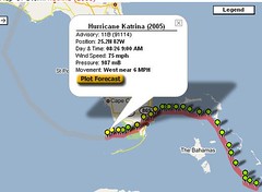 The Central Florida Hurricane Center has an unofficial Google Map of the path of Hurricane Katrina across southern Florida. The map lets you see the track of the storm, zoom in to any time/location coordinate, and overlay satellite imagery on top of the map. It's just one of hundreds of so-called "mashups" that combine data with software like Google Maps that uses open APIs.
Many of these mashups have government applications. In addition to storm data, there's pothole data in New York; crime in Chicago; and sex offenders around the country, as detailed in an Associated Press article.
So far, although much of this stuff is based on government-supplied data, we haven't seen any mashups created by government agencies. This would be really be e-government and citizen-based government in action. Do you know of any? Would your agency consider it? Why or why not?