Google Maps adds live public transport updates

Google has added a feature to its Maps tool that tells people how long they have to wait until a bus arrives at their stop.
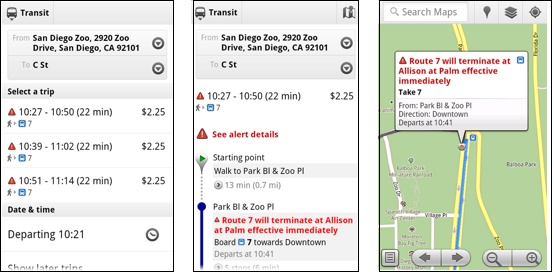
Google has added a feature to its Maps tool that tells people how long they have to wait until a bus arrives. Photo credit: Google
On Wednesday, the company introduced live public transport updates, including departure times and alerts about service interruptions, for Google Maps for desktops and mobile. The tool is kicking off with coverage for four US cities — San Francisco, San Diego, Boston and Portland, Oregon — and in Madrid and Turin in Europe, Google said in a blog post.
"Since this is a new feature, we elected to work with a few innovative partners, to develop the feature and make sure it actually works with the business constraints of transit agencies," a Google spokesperson told ZDNet UK, but was unable to give details of the selection criteria.
To use the feature, people click on a transit icon on a map to get alerts about delays or other service interruptions, as well as up-to-date departure times. They can also search for a station and click on the result to get the same information.
In addition, route directions provided by Google Maps will deliver any relevant service alerts, the company said.
Google could not say whether or when the new map feature will arrive for UK cities. However, it seems likely that the tool will eventually cover London, as the company intends to introduce it wherever there is real-time transportation data to draw on.
"Live transit data is becoming available within an increasing number of transit agencies across the world and we aim to offer our product wherever the information is being provided," the company's spokesperson said.
No downloads or updates are needed to start using the transit layer, according to Google. It is available for the latest version of Google Maps for mobile, which requires Android 1.6 or above, and on supported desktop and mobile browsers.
Microsoft has integrated London bus and tube data into Bing Maps to allow people to find the best public transport route to a destination. However, unlike the Google Maps tool, Bing London Journey Planner does not provide real-time information, relying on published schedules instead.
Get the latest technology news and analysis, blogs and reviews delivered directly to your inbox with ZDNet UK's newsletters.