Open data vs the flood: How high-tech is helping Venice deal with high tides

The San Francesco del Deserto island, in the Venetian lagoon, isn't the first place likely to spring to mind if you think about technology. The Franciscan friars of the beautiful convent that dominates the island are wise men for sure, but geeks they are not.
Yet this sacred place, where Francesco went ashore in 1220 on his way home from the Fifth Crusade, is not immune to the appeal of open data. In fact, it's one of the few places involved until now in the Acqualta project, the brainchild of the #opendatavenezia group — a collective of open data activists that aims to monitor the tide level through the use of wireless sensors spread across the lagoon.
The high water (acqua alta in Italian) in Venice can sometimes be a real problem, with tides reaching as high as 1.5 metres above sea level and quickly cutting off large parts of the city. That's why the lagoon is already filling up with measuring instruments owned by local and central authorities, such as those of the Centro Maree, the Istituto di Scienze Marine (known as Ismar, a branch of the National Research Council) and the Istituto Superiore per la Protezione e la Ricerca Ambientale (Ispra, controlled by the Department of the Environment).
The Acqualta project has a different approach, though. As Luca Corsato, a member of #opendatavenezia, told ZDNet, it's "a civic hacking action".
"We want to test the potential of citizens as sensors," Corsato says, "engaging residents in the production of data. It's a bottom-up approach in which data is a shared resource, as opposed to the traditional idea of information being owned and distributed by a central authority."
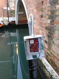
The group is therefore working to convince families and businesses to "adopt" and install in their building a small, lightweight and solar powered sensor which every few minutes will wirelessly communicate the height of the water to a dedicated server.
The data is gathered in a database and posted on Twitter, for everyone to see. When the tide is below 60cm above sea level, tweets are sent every half an hour; at high tide, the frequency increases to one tweet every few minutes.
Up until now, three sensors have found their home in the lagoon, all of them in the historical centre of Venice (in the Ognissanti and Ruga do Pozzi areas): one is hosted in a hotel, one in a building site, another in a private house.
Two more are coming soon: one in the aforementioned island of San Francesco, where the Minorites have already agreed to host one, and another in the nearby island of Burano. Another 10 sensors will be installed as soon as hosts for them are found.
"The best thing would be to place them in areas as distant from each other as possible, in order to provide redundancy to the system and to better understand how the tide moves in lagoon," Corsato says.
The only requirement needed to participate in the program is to possess a porta d'acqua, a water gate that usually coincides with the side door that was used (and, sometimes, still is) to access a building arriving by boat. The device itself consists of a single plastic tube which contains a level sensor, a SIM to transmit the data (which can be shared either over wi-fi or GSM) and a battery to use as a backup power source when the sun is not enough.
"The cost of hosting and maintaining the sensor is minima and the data produced is perfectly consistent with those published by the Centro Maree or by the Ispra, as the tests performed so far clearly show," electronic designer Oreste Venier, whose company Eraclit developed and patented the instrument, tells ZDNet
Venier started to develop the sensor after the floods that vexed the Veneto region in 2010, when several rivers broke their banks, flooding the land, and forcing 4,500 people to leave their homes and causing two deaths.
A small instrument for measuring the height of the rivers can help the local authorities better identify the places where the water would most likely overflow, Venier says.
Venier has offered his lightweight sensor to various local government, but they all asked for some kind of reference, a field trial of how the instrument worked. The tool had already been trialled by Veneto's Regional Agency for Environmental Protection and Prevention (Arpav), where it was used to measure the level of lowland rivers and mountain reservoirs, but this was not enough.
"They said: your company is based in Marghera, just outside Venice, why don't you test the sensor in the lagoon first?" he says. And so they did. Eraclit partnered with the #opendatavenezia group and offered them 15 sensors for free: the Acqualta project started to take shape.
The planning phase started in April 2013, while the first tests began in October 2013; less than two months later, at the end of November, the project was presented to the public in the town hall of Ca' Farsetti.
Though not directly involved in the Acqualta experiment, the municipality of Venice has strong ties with the #opendatavenezia group: some of the collective's members work for the local administration, and others have helped the politicians draft the town's open data policy.
"In Venice, since May 2013 all the data produced by the administration is public by default. Access is restricted only in specific, sensitive cases," city councilman Simone Venturini tells ZDNet. Venturini, by the way, is also a member of the #opendatavenezia group, a double role he is comfortable with, although one might wonder if there is any contradiction in being part of the administration that backs the Centro Maree's network of sensors and being also one of the promoters of this 'alternative' project.
But, according to Venturini, "the goal of Acqualta is absolutely not to replace the Centro Maree — which, it's important to highlight, not only measures the water level, but also has to try to predict any increase. The project's mission is rather to help citizens better understand the culture of open data."
That doesn't mean that the experiment might not have any practical application, however. "Our hope," he says, "is that in the future the adoption, even on a small scale, of this low cost monitoring technology could help the government organisations save money on tide measuring and concentrate their limited resources on [flood] predictions."
Not to mention the fact that, with all historical data about the lagoon's water level available on Twitter and through the Acqualta website, developers will be able to build softwares on the top of them. One sample app for iOS has already been developed.