CSIRO eye in the sky hunts down natural disasters

The CSIRO has developed a new network to help disaster response efforts, by delivering visual data on natural disasters to emergency services across the Asia Pacific region.
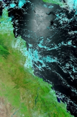
Satellite picture of flooding over Queensland. Credit: NASA
The network uses details from satellite pictures to obtain data on regions where there may be fire, flood or earthquake and then present it visually through a network of Web geographical information services.
"We have a number of processing algorithms that create a number of information products," CSIRO group head Dr Alex Held explained, such as overlaying known fire locations on a map. "It's not just pushing a lot of data across the world, but creating easy to read information for emergency services," Held said.
The trick is to be able to get information from satellites into a readable format as quickly as possible after the satellite sends it, Held said. "These are big images and they need to be crunched," he explained.
Satellites fly over an area a couple of times a day to make a snapshot of the region, Held told ZDNet.com.au. Each time they pass, they transmit around 1GB of images down to a receiving station, for example, in Alice Springs.
After the images are received they are decompressed and the data analysed to detect unusual phenomena -- for example, using an algorithm to find the location of fires by detecting hotspots in thermal images.
The result is a very small file of only a few KB which can be sent to either the east or the west coast of Australia containing the coordinates and the temperature of the fires. This information is used to create Web interfaces such as the one which appears on the Geoscience Australia Web page, where small flame symbols on a satellite image of Australia show where fires are burning across the country.
In the case of flooding, the process is not yet fully automated. A human being is still needed to interpret the data to show the outline of the flood area. "The current push is to get the flooding [system] happening properly," Held said, saying that countries such as the Philippines have acute need for the system. "It's a matter of writing the necessary software to make sure it happens," he continued.