Google Earth ventures 'into thin air'
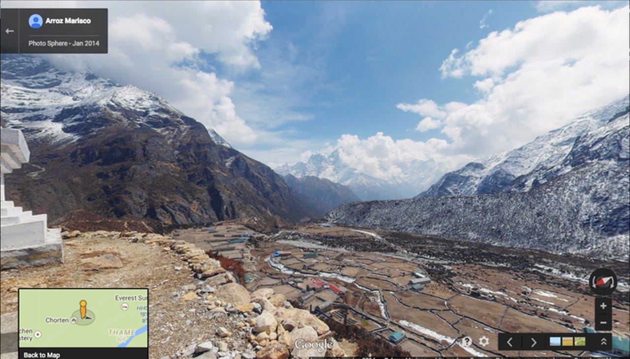
Recently announced by the search giant, this project takes viewers on a breathtaking journey through Sagarmatha National Park in Nepal, home to Mount Everest, the highest mountain in the world, which stands at 8,848 metres. You can swoop down from high above the terrain and float into the village, view it in 360-degree glory (thanks to the innumerable 75-megapixel shots that have been digitally stitched together), and follow a trekking path along a river that takes you to yet another village or monastery much like you would see on the streets of any city documented by Google Street View to date.
The project came about when Google roped in Kathmandu-based startup "Story Cycle" and 55-year-old legendary Nepalese mountaineer Apa Sherpa for the project. Apa Sherpa is no ordinary mortal. He reached the summit of Everest a mind-boggling (and record-breaking) 21 times before retiring and starting an educational charity.
According to the AFP story, Google first orchestrated a "digital mapping session" in the iconic town of Namche (resting spot and springboard for many an Everest expedition), where around 50 locals advised the team on what was worth capturing.
Then, armed with just two tripods, special lenses, and a 15-lens custom-built "Trekker" unit designed for backpacks, and led by the indefatigable Apa Sherpa, project members went on an intensive walkabout in Sagarmatha National Park. Over 11 days, they captured glorious images of the landscape, monasteries, schools, and clinics while traversing the area.The result is nothing short of glorious, with 45,000 dazzling images of remote mountain villages and towns of the Sherpa community captured for the first time in such a comprehensive manner for the world to enjoy.
I suppose one legitimate question that could crop in a reader's mind is: So what? Cool idea, but ultimately, why should we care about this versus all the other, perhaps equally spectacular, Google Earth projects that are out there?
Well, for someone like Apa Sherpa, who first climbed Everest as a porter much like all the other Sherpas in his community who are known for their otherworldly climbing skills and toughness, this is a great opportunity to draw attention to the condition of his brethren.
When tragedies occur, and they do with frightening regularity -- just last year, 16 Nepalese guides, including 14 members of the Sherpa community, died in an avalanche -- the ones who invariably bear the brunt of the hit are the Sherpas. They have become nameless, faceless footsoldiers in the attempts of outsiders' fantasies of wrestling Nepal's mountains to subjugation. Apa Serpa thus describes his first ascent of Everest as "a dream that had never been mine".
Latest news on Asia
But now, Apa thinks that technology can help give something back.
"Thanks to Google Street View, everyone can see these villages and understand that people here need help. Hopefully we can then raise funds to build more schools and hospitals for them," he said in the AFP article. "My dream is that one day, young kids in Nepal won't have to risk working on the mountain as porters or guides, they will be able to get an education and build better lives for themselves."
Whether this does occur can only be conjecture. I first remember getting sucked into the world of Everest and mountaineering through Jon Krackauer's articles in Outside Magazine that chronicled an Everest climbing expedition that he was on that went horrifyingly wrong. Many who read his subsequent book, Into Thin Air, and had never been to Nepal could only conjure up in their mind's eye the kind of place that the Sagarmatha region could be.
Now, suddenly, you can hurl yourself from your living room sofa headlong into the Sherpa community in a kind of immersive way that you would have never imagined, giving form and life to words that extend the imagination into the realm of the here and now, extending the possibilities of tourism and helping people in ways that were never possible before. Others will say that it robs travellers of the thrill of an experience by giving them way too much of something that they should be savouring in an undiluted fashion without this sort of digital priming.
For people like Apa Sherpa, if it brings more money and resources to educate future generations of Sherpas who can navigate other careers rather than just treacherous mountains, it would have been well worth the effort.