Pitney Bowes launches location intelligence tool GeoVision

Pitney Bowes has announced the launch of its location intelligence tool GeoVision, powered by the datasets made available by PSMA Australia and DigitalGlobe through their product Geoscape.
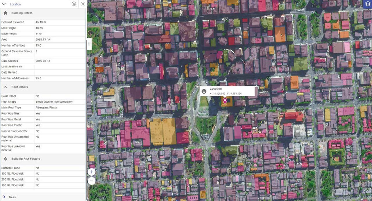
Geoscape, which was officially launched last week, uses a combination of satellite imagery, crowdsourcing, and machine learning to capture attributes of the built environment including building footprints and heights, land cover, tree heights, rooftop materials, swimming pools, and solar panels.
Latest Australian news
The information covers Australia's 7.6 million square kilometres, and represents more than 20 million buildings.
Pitney Bowes' GeoVision has now taken PSMA's datasets, overlaid additional building and land attributes drawn from its own data, and created a tool that allows businesses to visualise, analyse, and ultimately make use of that data to inform decisions.
GeoVision will be integrated into a broader location intelligence offering, as well as distributed as a stand-alone product.
Nigel Lester, managing director at Pitney Bowes ANZ, said GeoVision has an ever-growing number of use cases across sectors such as government services, insurance, real estate, telecommunications, and utilities.
For example, local governments would be able to use GeoVision for flood modelling and identifying illegal building developments and unregistered swimming pools, while state governments would be able identify bushfire and flood risk for emergency management.
Insurance companies would gain a better understanding of the risk profile of their existing and prospective customers' properties based on information such as building type, roof material, and the distance and height of nearby trees and bushland, the company said. The information could then be used to guide the pricing of insurance policies.
The telecommunications industry is also great example of how an organisation can combine location intelligence and big data -- in particular, network data -- to provide a real-time understanding of the network quality and coverage, according to Lester.
Lester, who previously told ZDNet that businesses have not capitalised enough on the opportunities location data presents, believes GeoVision will be of great value to businesses that embed it into their back-end systems, with this kind of analytics tool essential for improving service delivery.
The Australian government's Digital Transformation Office similarly announced the launch of Link, a nationwide location information knowledge platform that makes spatial datasets more accessible and easier to discover, last week.
"Accurate location information is a key influencer of productivity," Assistant Minister for Cities and Digital Transformation Angus Taylor said in a statement.
"Having access to consistent and accurate position and road network data enables cooperative intelligent transport systems such as vehicle charging, and freight, logistics, and container management.
"This allows for faster and more efficient supply of goods to market, which is critical for the future of our smart cities and regional networks."
Link is being delivered under the Foundation Spatial Data Framework, a national program aimed at improving the delivery of location data to the broader economy.