Ready for your hyperspectral close-up?

Any self-respecting technophile has checked out their house at least once on Google Maps and marveled about what they could (and could not) see. But the way that we "see" things via satellite images in the future could be dramatically different, if emerging technologies from the likes of military technology contractor Raytheon.
The technology I'm talking about is called hyperspectral imaging, a technology that creates unique spectral images of objects based on any number of factors such as the density, heat and other information. By comparing these images with a database of known substances and images, you can figure out what's on the ground. Raytheon last week won a contract from the U.S. airfare to produce what is being called the first airborne tactical hyperspectral sensor system.

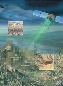
Hyperspectral sensors trade spatial resolution (what the eye sees) for spectral resolution. Since every material has its own unique spectral signature, hyperspectral sensors can identify objects on the ground that would otherwise go undetected. Credit: Raytheon
The intent of the system, called the Airborne Cueing and Exploitation Systems Hyperspectral (ACES HY), is to "identify targets based on their spectral characteristics. For example, while looking at a traditional image of an area on the ground might lead you to believe there's lots of green in a particular area, a hyperspectral image could reveal that what you THOUGHT was grass is actually artificial astroturf, which can look the same to the naked eye. Think that roof is just a roof? Well, actually, a hyperspectral image could tell you there are dozens of solar panels installed.
The video provided (at the end of the post below) by Raytheon walks you through how the technology works, so I'm not going to dissect that in great detail.
Aside from the obvious military applications, there are any number of potential uses for the technology that are more humanitarian or green in nature. I discussed some of those applications, which have been at least partially validated in previous tests of the technology, with Raytheon executive Tom McDonald, who is director of the company's DoD, Civil and International Space group.
Here are two of my favorites:
- Toxic clean-up: Apparently certain hazardous materials reflect sunlight in a very different way than other materials. McDonald said that the test satellite that was a lot during the recent earthquakes in Haiti and Chile was used for first responders, who were trying to rescue victims without putting their own crews in danger.
- Smarter farming: In the future, hyperspectral imaging might be applied to commercial farming operations that could use the images to observe the "health" of farm areas. The images of turgid leaves, for example, are slightly different from those that aren't getting enough water. The effects of fertilizer and pesticides could be more closely examined, McDonald said.
Of course, your company wouldn't necessarily go out and buy a satellite for hyperspectral technology. "This shouldn't be a science experiment every time we do it," he said. But in the future, an agricultural operation or community might be able to buy imaging and data analysis services that are focused on their needs.