What can undersea cables tell us about earthquakes?

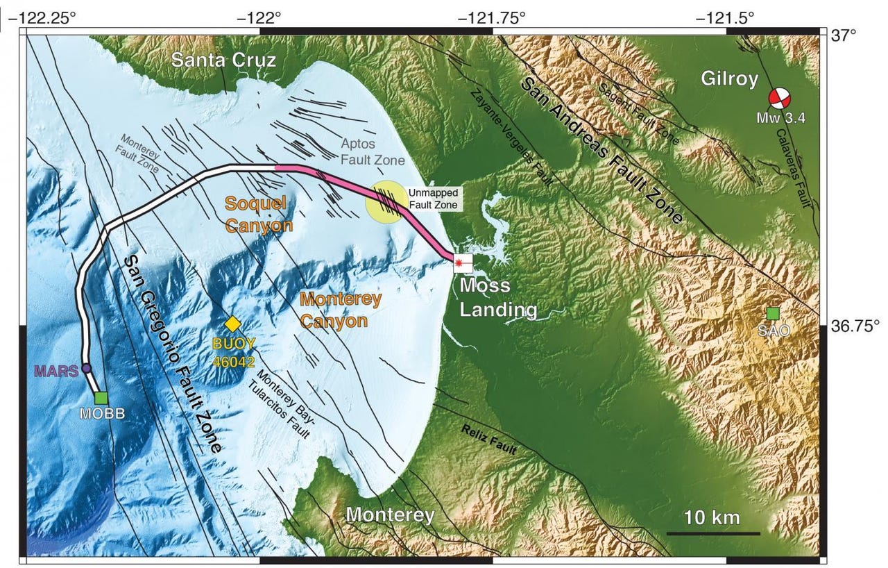
Researchers employed 20 kilometers (pink) of a 51-kilometer undersea fiber-optic cable as a seismic array to study the fault zones under Monterey Bay. During the four-day test, the scientists detected a magnitude 3.5 earthquake 45 kilometers away in Gilroy, and mapped previously uncharted fault zones (yellow circle).
Our existing telecom infrastructure has new potential. A team of scientists used fiber-optic cables that were already installed under California's Monterey Bay to detect quakes, access fault information, and measure ocean waves.
Typically, scientists use instruments called seismometers to study earthquakes and keep an eye on the fault lines that formed throughout our planet's history. For practical reasons, most of the seismometers are land, although 71 percent of Earth's surface is covered in water, according to the US Geological Survey. At the shaky California coast, scientists found a convenient way to fill in the blanks.
In a paper appearing this week in the journal Science, researchers from the University of California, Berkeley, Lawrence Berkeley National Laboratory (Berkeley Lab), Monterey Bay Aquarium Research Institute (MBARI) and Rice University describe the experiment. They repurposed an existing fiber-optic cable that was originally installed on the seafloor for oceanography purposes.
"We turn a science cable into 10,000 components of 10,000 seismometers, basically, and that lets us do dense, large array seismology," explains lead author Nate Lindsey, PhD candidate at UC Berkeley.
We spoke with Lindsey and fellow researcher Jonathan Ajo-Franklin, of Rice University and Berkeley Lab to find out what they learned about using telecom cables to monitor earthquakes and other seismic events. During a four-day experiment, they recorded a 3.5 magnitude quake and seismic scattering from underwater fault zones in the region where the continental shelf goes into the deep ocean.
Why It Matters
The West Coast science hub of Monterey Bay is located in a seismic hazard zone, where the San Gregorio and San Andreas fault systems connect. Even in this seismically active area of the US, there isn't a lot of data about what's going on with the Earth's surface because it's covered by the ocean.
"It's hard to work in the ocean. It's costly and you can't put sensors down for a long time," Lindsey says. "Having access from shore to do this fiber optic sensing method allows us to get access to fault information and also make measurements about ocean waves."
This new technique could help solve some of the biggest challenges with current methods of monitoring undersea quakes. Traditionally, scientists will use ships to travel to the ocean and drop instruments into the ocean for seismic monitoring. But the sensors have limited power and they're operating under pressure from the water.
The Monterey Accelerated Research System (MARS) cabled observatory, a node for science instruments on the ocean floor 891 meters (2,923 feet) below the surface of Monterey Bay, is connected to shore by a 52-kilometer (32-mile) undersea cable that carries data and power. About 20 kilometers of the cable was used to test a new concept called photonic seismology on the seafloor.
"The other component is getting the data back," Ajo-Franklin explains. "Because when you're on the bottom of the sea floor, you can't use a radio because salt water has very high conductivity. So you can't do radio wave telemetry."
How It Works
In order to turn undersea cables into seismometers, the researchers used a technique called Distributed Acoustic Sensing (DAS). Inside the cables are optical fibers which are basically long strands of glass. DAS involves shooting quick pulses of laser light down the fiber and detecting bits of light that scatter back to the laser source due to natural impurities in the fiber.
When the earth's surface vibrates and shifts, it pulls the cables, so a detector can identify these small changes in the backscattering.
"We're using laser light and back scattering and interferometry to make these very sensitive measurements of strain at every location on the fiber," says Ajo-Franklin. He adds, "And because we know the speed at which light travels in the fiber, a time is equal to a distance along the fiber, so instead of it just being one measurement of pull, you're making 10,000 measurements at all these different spatial windows."
This technique yields an unwieldy amount of data.
"You're doing it at kilohertz or 500 samples per second in our case, and so that generates terabytes of data per day," Lindsey says.
The Bigger Picture
In theory, you could use all the telecom infrastructure that we already have to look for earthquakes. The New York Times points out that although wireless and satellite technology are prevalent, good old fashioned cables are still the most efficient way to send information across oceans. The wireless connectivity that we enjoy for communication and entertainment is actually connected to nearly 750,000 miles of cable that stretches between the continents.
There are several expensive logistical challenges, such as installing the DAS equipment and installing and transferring all that data. Plus, there's a risk that the seismometer instrument will interfere with the original purpose of the cables, telemetry. In the future, the researchers suggest that this problem could be solved in a similar way to the spectrum sharing standards that we use to optimize wireless communications.
"Instead of having a dedicated fiber, which is just used for something, you can imagine you have a dedicated slice of wavelength," Ajo-Franklin says.
It might be impractical to turn all of the undersea cables into seismometers, but there are some higher priority regions that would benefit the most: offshore fault zones. Retrofitting undersea cables with this new capability could give scientists the ability to continuously monitor high-risk zones that were previously hard to reach. This could help shave a few seconds off early warning systems for earthquakes and tsunamis.
At the moment, this new research is helping earth scientists observe and understand fault systems and the seismic activity that hides beneath the ocean.