Google Earth in 4D

Update:
Subscribe to this feed to learn about Google Earth updates as they happen.
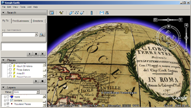
Google skipped right past the third dimension and landed directly in the fourth (time) by offering historical maps on Google Earth. Now you can travel back in time -- for example, I am looking at the globe of 1790. Don't expect detailed high resolution photography from days gone by, but it's still interesting to see old maps overlaid on the satellite imagery of today.
Playing with layer transparency on the overlaid maps gives you a good sense of how things have changed over the years -- especially when looking at more detailed maps like New York 1836 or London 1843.
Currently, maps are available for:
- World Globe 1790
- North America 1733
- United States 1833
- Lewis and Clark 1814
- New York 1836
- San Francisco 1853
- South America 1787
- Buenos Aires 1892
- Asia 1710
- Tokyo 1680
- Middle East 1861
- England, Wales 1790
- London 1843
- Paris 1716
- Africa 1787
- Australia Southeast 1844
- Various other maps from Map Finder
Update:
To use this new feature, expand the Featured Content -> Rumsey Historical Maps in the Layers panel.