Wonobo beats Google to launch street view maps for India

While Google and other search/mapping companies have had quite a struggle with the Indian authorities to get permission to take images of city streets, a Mumbai-based mapping company has come to the fore with a lot of what Google had probably planned to do.
Wonobo is a service launched on October 15 by Genesys International, founded by brothers Sol and Sajid Malik in 1995. They have captured several images of streets across various cities in India and stitched them together to create 360-degree panoramic views of the streets almost like how Google has done in other parts of the world.
This is quite an amazing product startup that has trumped even Google, which has been struggling to roll out its street view project in India, with issues in getting permission from authorities. So how is it that they were able to do something like this?
As mentioned by Sajid Malik, in the Times of India, what helped them was that their parent company had been working with the government for many years for their mapping service.
Read this
"For street view, the government, including the defense ministry and the Survey of India, threw a lot of regulations at us. We painstakingly fulfilled their requirements, including not taking pictures in sensitive areas," he said.
Also Genesys has the edge since it is a local company that has been hosting the data in local servers and the company has so far been creating map content for others such as Navteq (provider of electronic navigable maps), Nokia and Bing.
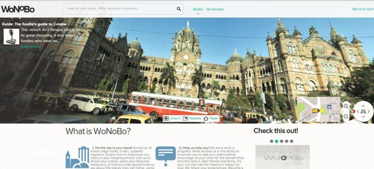
Wonobo's primary feature the street view service gives a map on the left side of the screen and street view on the right you can toggle between the full view of the map and the street view being zoomed. And after which you are able to click anywhere in the map to load the respective street view. What’s interesting is the way you can panoramically view the entire area and though they are still images, give you a clear perspective of finding locations, going down to details such as the name of the shop, the street, and even billboards that were present when the pictures were clicked.
According to Medianama, the service will cover 54 cities, which covers 70 percent of the urban economy of India. Initially 12 cities will be in the launch, and will be rolled out to 20 more a few weeks later. In addition to that they have tagged 10 million points of interest, across cities and homepages have been created for them, of which 4.5 million are commercial places. As mentioned in the article other than the street view, that they'll also include.
- Inside Maps
- Direction and Routing
- Walking Tours
- Guides
- Stories
And as mentioned by Malik in the Medianama article, there were quite a lot of efforts that needed to be taken to get the regulatory issues taken care of.
"We have all the permissions from the Ministry of Defence for all the sensitive areas, but it's not covered. We've worked with them. There is a need to take permissions both at a city level, and at a central level. It's fairly complex. We have, for the new Map Policy; it's vague in its interpretation. What we typically do is that whatever map data we create, we get it whetted by Survey of India. You need to go through the process of getting it cleared with them," Malik said.
Quite a laudable effort I must say. Besides the popular and very local areas in my city Mumbai like Marine Drive and Mumbai CST railway station I could also locate remote suburbs and the adjoining satellite city, Navi Mumbai as well and they had street views down to the detail.
It does take some time to get used to the navigation, especially with some areas not loading up the street view and you get the message, "Sorry our cameraman appears to have fallen asleep here". Also searching within cities is a little challenging, however there are tips that they’ve given to make the search process easier. A little more intuitiveness is always welcome on that front.
Also as expected, when I tried out some secure locations in Mumbai like Anushaktinagar, or distant across the sea such as Elephanta caves I found no result for the street view.
They are planning to go mobile soon and that's something I’d love to check out especially being a travel blogger as well it's quite a boon while traveling within India when you're looking for places you have no clue about, in crowded locations. For now, this is quite a start and I'd certainly look forward to further progress and maybe even cover their journey depending on where they go from here. Do try it out and let me know what your views on this app are.