Psion/Blackroc GNSS device delivers centimetre accuracy

Earlier this week I met with Tony Jephcott, CEO of data capture specialist Blackroc Technology, and Jonathan Brayshaw from Psion, on whose modular Workabout Pro 3 handheld Blackroc's new Procyon device is based. The Procyon's claim to fame is that it's the first handheld GNSS (Global Navigation Satellite System) device that, when suitably configured, can deliver 'pinpoint' (1-2cm) accuracy. This makes it very interesting to surveyors and other professionals who require quick and efficient high-precision geo-location.
The Procyon range, which adds a 2.1-megapixel camera and a GNSS module to the basic Psion Workabout 3 handheld, starts with the W100, whose GPS receiver's standard 15m accuracy is boosted to 1-2m using SBAS (Satellite-Based Augmentation System). SBAS services such as EGNOS (European Geostationary Navigation Overlay Service) use geostationary satellites to transmit information on the reliability and accuracy of the signals from medium-earth-orbit GPS satellites (and other GNSS constellations such as the Russian GLONASS system). This device, which sells for a low four-figure sum (Blackroc is coy about revealing detailed pricing), is suitable for low-level applications such as collecting geo-tagged images.
The next model up, the Procyon W200, improves GPS accuracy to sub-metre (70cm) levels by augmenting SBAS with ground-based Differential GNSS (DGNSS), which uses a collection of accurately-surveyed base stations to calculate errors in the satellites' 'pseudoranges' and broadcasts correction information via a cellular connection or UHF. This is an entry-level professional device, suitable for general-purpose GIS (Geographical Information System) data capture, for example.
For high-end surveying applications, the dual-constellation (GPS and GLONASS) Procyon W300 delivers accuracy in the 30-50cm range, while the top-of-the-range W400 offers the highest resolution — down to an extremely impressive 1-2cm. At this level, the device must be mounted on a pole, as it's not possible to hold it steady enough in the hand to get an acceptable reading. The W400 (which can be a software upgrade from the W300) achieves its accuracy by using dual satellite carrier frequencies and employing Real-Time Kinematics (RTK) to provide a further layer of error correction.
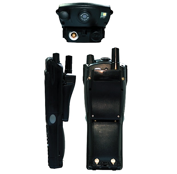
The 750g Psion/Blackroc device's general specs include a 624MHz PXA270 processor running Windows Mobile 6.1, an integrated GSM module, Wi-Fi (802.11b/g), an outdoor-readable 480-by-640-pixel LED-backlit display, a choice of keyboards (full alphnumeric or numeric only) and the aforementioned 2.1-megapixel camera. Battery life is quoted at six hours with full GNSS connection. It's rugged to IP65 level, and can withstand drops from up to 1.5m.
Psion's latest, even more modular, handheld is called Omnii — described by Jonathan Brayshaw as "a Swiss Army Knife platform" (the first product in the range was last year's XT10). Blackroc's Jephcott confirmed that the Procyon GNSS device will move to Omnii, whose improved internal I/O will enable some significant enhancements, including a better camera and a laser measurement device that will allow the user to stand in one place and fix the position of surrounding buildings or inaccessible infrastructure elements such as power lines. Jephcott also mentioned a 'revolutionary antenna', but declined to elaborate at this time — a "major announcement" is expected "possibly by the end of December".
A key feature of the Omnii platform is its unique community of hardware developers, IngenuityWorking, among whom Blackroc is a leading light. This enables hardware (and software) add-ons to be 'co-developed' by Psion's partners — a process that simply wouldn't happen within traditional 'monolithic' manufacturers, according to Brayshaw.
It's early days, both for community-developed products and the GNSS market. For example, Jephcott told of a major water authority admitting that 20 percent of the holes it digs are in the wrong place, because the maps of its pipe systems are insufficiently accurate. A Procyon-equipped worker logging the pipe locations accurately as they're being laid would banish such inefficiences at a stroke.
Further down the line, Jephcott sees Blackroc becoming involved in the 'internet of things' and people-tracking within buildings. Of course, GNSS doesn't work accurately enough (if at all) indoors, so it's envisaged that other radio technologies — Wi-Fi and Bluetooth, for example — will be employed here. Another alternative for mapping buildings accurately is the use of psuedolites, although this will be more expensive than making use of existing Wi-Fi or Bluetooth infrastructure.
Clearly there's plenty to look forward to in the modular handheld/GNSS space. We'll try to keep (accurate) tabs on it.