Google Maps gains weather layer with forecasts

Google has added a weather layer to Google Maps, allowing users to see the current temperature as well as forecasts in any location.
The company announced the addition of the layer in a blog post on Thursday. The service takes its weather conditions data from Weather.com, while the cloud coverage that can be viewed when zoomed out is derived from the US Naval Research Lab.
"Today, we're adding a weather layer on Google Maps that displays current temps and conditions around the globe, and will hopefully make travel and activity planning easier," Google user experience designer Jonah Jones wrote in the post. "To add the weather layer, hover over the widget in the upper right corner of Google Maps and select the weather layer from the list of options."
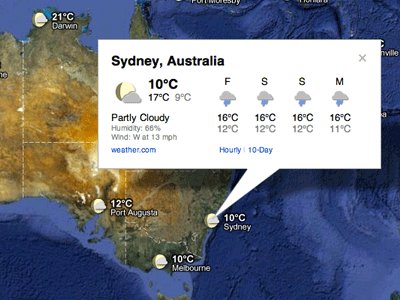
The standard view of each location's weather shows current conditions, with icons denoting sun, clouds and rain, but clicking on a specific city's weather icon brings up further details such as wind and humidity, as well as a four-day forecast. This view also makes it possible to click through to an hourly or 10-day forecast on Weather.com.
"Changing the units of wind speed (Mph/KMph) and temperature (F/C), and enabling or disabling the clouds (when you’re zoomed out), can also be done from the left-hand panel," Jones explained.