Mobile software Monday: Spb Traveler 2.0 for Windows Mobile

I am quite impressed with the excellent applications developed by Spb Software House and I just wish that they were able to develop them for S60 and/or BlackBerry devices too. One of their latest titles that is a perfect fit for me and my regular travels is Spb Traveler 2.0. The software is designed for the mobile road warrior and offers several tools to help make your travel a much better and more organized experience. Please visit my image gallery for screenshots of the software running on my Palm Treo Pro. You can also view the video below to see the software in action.
| Image Gallery: There are several useful modules within Spb Traveler 2.0 that should appeal to the road warrior. | 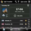 | |||||
I installed Spb Traveler 2.0 on the microSD card in my Palm Treo Pro and it installed as smoothly as any other standard Windows Mobile application. The application actually does require a fairly significant amount of memory for a mobile application, 9 MB for QVGA and 11 MB for VGA displays. It is also only available on touch screen devices. As you can see in my video and screenshots, I think the animations are a big reason for such a large memory footprint of the application.
When you first launch Spb Traveler 2.0 you are taken to the weather/time/city info tab where you can add cities you desire to keep tabs on. By selecting the upper right icon you can also create a meeting, calculate tips, map the city on Google Maps, or manually update pictures of the city. The currently selected city appears on the top half of your display (may be different orientation for different resolution devices) and the layout has a photo of the city with an icon of the weather for that day and the high and low tmps below this photo. Over to the right is the local time and date with a link to city info below this. Below the selected city all of the other cities you have setup appear with the country flag, city name, local time, local weather icon, and local current high and low temps.
Tapping on each of the four areas for the focus city takes you to detailed information displays. When you select the photo then you will be taken to a display that lets you view a slideshow of photos of the city (you do need an internet connection to download the photos). Tapping the weather takes you to more details and a 5-day forecast. You will see morning, day, and evening forecasts. Selecting a day will take you into even more details, including humidity, wind speeds, and a breakdown of weather forecasts throughout the day. You tap the back arrow to go back to the tab you were originally at before viewing the details.
Selecting the time and date takes you to a display that show you the GMT offset, local offset, sunrise and sunset times, and shows you your location on a small world map.
If you want to view more city info then you will need an internet connection and then you will be presented with links to city info that you can then open up with the browser. You can also select to download images on this display.
The next tab to the right gives you access to a trip manager where you can create, edit, load, or delete trips and add items to your trip. When you select to add an item then a pop-up appears in a 3x3 grid with options to add a flight, hotel, train, car rental, cruise, bus, meeting, activity, or note to your trip. Each one of these modes of transportation or activity has its own custom entry screen that you can see in my video and image gallery. In the flight item you can actually use your internet connection to try to search for the flight details.
The third tab in Spb Traveler 2.0 presents you with a 3x3 grid of tools for the traveler. The tools include a tip calculator, unit converter (even includes most of the special nautical ones I use), flight finder (internet connection needed), clothing converter, currency converter (data connection gives you the latest rates), geography game, foreign language phrase book, time converter, and options.
The flight search is powered by OAG and is subscription free so this is quite an advantage over other similar software.
The geography game is a fun way to test your knowledge of the world. You can select to test your knowledge of world capitals and/or flags. If you select the animation check box then your answer will appear dynamically on a virtual globe (gives you a Google Earth kind of experience). The game is challenging and your score is tracked so you can compare and work to improve your knowledge.
The phrase book is a VERY handy tool that will definitely have me taking along the software on my next international trip. You can choose from 17 included English to foreign language phrase book with the most popular included. I looked through the Spanish/English one and found a ton of helpful phrases inside the book. You have the ability to get more phrase books too, with a data connection. Within a phrase book you can scroll down all the phrases or select to view them by category (right soft key). It is amazing how many phrases are in this and the phrase book function itself may make it worth purchasing the software.
By selecting the Options icon you can setup the default units (for temperature, speed, and pressure), establish when weather and currency downloads will occur, set the default currency, and manage the cache. You can specify where information is cached, including on an external storage card. Data is cached for city images, city guides, satellite images, and flight searches.
The final tab in Spb Traveler 2.0 is a virtual globe that dynamically spins and rotates to show you the cities you have selected in the first tab. The time, date, and weather conditions are shown for each city. The globe also shows you where day and night are occurring all over the world. Tapping the first icon on this display lets you toggle night, sky, animation, cities, and trip animations. You can zoom in one level by tapping the + icon or zoom back out for the entire earth. Tapping the North icon orients the globe with North up instead of angled towards your selected city. The animations and software is powered by the Spb Mobile Shell.
A Today screen plug-in is also provided so you can view the time, date, and weather info (5 day forecast) for your entered cities. When you create a trip, time sensitive data (flight times, check in at hotels, etc.) will appear in your calendar database.
I wasn't expecting so much to be packed into the program and figured it would just have a currency converter, time zone converter, and have some trip tracking features. Spb Traveler 2.0 is quite powerful and functional. It would probably be easier to enter all the data for a trip on a desktop version of the software and then sync it up with the mobile version, but Spb Software House has still made it as simple as it can be on your mobile phone or PDA. You can download and try out a fully functional version for 14 days. If you find you like it then you can purchase it for US$29.95.