Where's Bin Laden? New theory, Google Earth offer clues

A couple of geography professors at UCLA have done some legwork that just might help the U.S. get closer to capturing Osama Bin Laden.
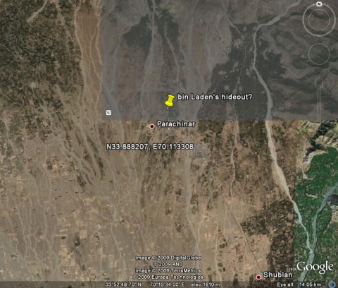
It brought it to the attention of ZDNet's own Andy Smith - a senior producer who sometimes doubles as a wannabe spy - who tracked those coordinates on Google Earth to better illustrate what and where the professors were talking about.In informal conversations in the Geography Department at UCLA, we began to ask ourselves if the biogeographic theories we use every day – theories that predict how plants and animals distribute themselves over space and over time – employed in conjunction with publicly available satellite imagery, could shed some light on this question (of Bin Laden's whereabouts). The outcomes of this musing... are our thoughts and experiment. By bringing these methodologies to bear, it is our hope that a long overdue debate might bring bin Laden back to the fore of the public consciousness – and possibly to justice.
Gallery: Finding bin Laden on Google Earth
It really is a fascinating experiment when you consider what they've done. The captions in the image gallery give a good insight into the process. Of course, now that the information is out there, the professors are hoping that the feds will take it from here.
Two UCLA professors and Google Earth can't do the whole job - though they've already offered the public a better update on the whereabouts of Bin Laden than the Bush Administration ever did.