Nearmap eyes 'reality-as-a-service' with 3D mapping technology

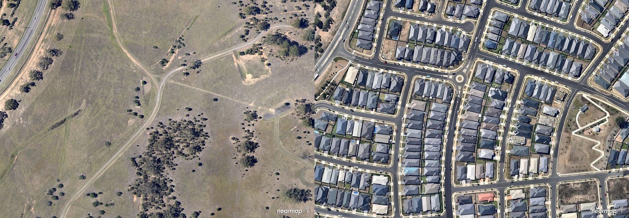
Jordan Springs in Western Sydney: 2009 vs 2017
Australian aerial imagery company Nearmap has revealed that it will be launching new technology later this year, expected to give businesses access to 3D models of what's on the ground.
Having already transformed an industry that was almost non-existent, Nearmap CEO Rob Newman told ZDNet that moving into 3D is simply the next phase of reshaping the industry.
The Australian Securities Exchange-listed company has already extended its camera system to process 3D data, as an extension of the 2D collection Nearmap has been performing for years.
"We are starting to collect that content in both Australia and the US, and that will be available as a streamed subscription service to our customers," Newman explained.
"We're capturing the real world, and then allowing our customers to stream it to be presented in a variety of different forms such as textured mesh or 3D visualisations."
Internally, Newman said the imminent offering is being called "reality as a service".
The CEO said Nearmap has committed to capture all capital cities in Australia as well as the top 50 percent of the US population centres by the end of this calendar year in 3D, noting that collection is already under way.
"Instead of going out in your car and checking overhanging tree branches or slopes of a roof, for example, all of that kind of information will be available in the third dimension," he said.
Newman found himself involved in Nearmap back in 2008, when founder Stuart Nixon approached the then-venture capitalist for investment. Nearmap was instead acquired by ASX-listed Ipernica that same year, and ran as a wholly owned subsidiary of Ipernica until 2012, when Nearmap was moved to Sydney from Perth and made the primary entity of the company after the success of its first product release in 2009.
"I remember speaking with Stuart, sitting in his lounge room and him showing me a demonstration of the technology and I thought this is going to change the world, and I've been passionate about it ever since," said Newman, who took up the role of CEO in 2015 after spending seven years on Nearmap's board.
The company's product development, technology development, and centralised functions all operate out of the Sydney headquarters. Nearmap also has a sales presence across the United States, where Newman said the company's product has gained a warm reception.
According to Newman, Nearmap created a new market when it introduced its product, as 80 percent of its customers in Australia had never before purchased aerial imagery.
In Australia, Nearmap captures imagery up to six times per year for most of the major cities and some of the larger regional towns. In the US, 70 of the country's largest cities are captured up to three times per year, with 270 cities captured at least once a year.
Insurance companies are using Nearmap to remotely assess claims; construction companies are using it to monitor the progress of developments; solar companies are using it to provide quotes and identify areas to target for new business; and local government agencies are using it to identify illegal developments.
While it's obvious what customers such as Ausgrid and Brisbane City Council are using Nearmap for, Newman said he's seen a whole range of use cases he never saw coming.
"One is Tasty Trucks, who drive the food vans around to construction sites so that the workers on site can buy lunch," he explained. "Tasty trucks was identifying where construction sites were using our imagery to plan the route of their food trucks."
Nearmap also has a partnership with Dutch telematics company TomTom.
"When you use your smartphone to plan your trip and it gives you the routing directions, they're also tracking where you're going, and when they find out that the route you took was different than what they have as a record, they look at Nearmap imagery," he explained. "They might find changes such as new roundabouts and change their routing directions as a result."
Newman believes there is real opportunity with Nearmap around driverless cars and autonomous vehicles in the future.
"When you think about what has happened with other subscription-type businesses like music and software, we're doing the same in this industry and I think there's enormous potential for this company," he said.
"Going into the third dimension and delivering reality as a service, we can't even think today about all of the applications that could bring, in the same way we would never have guessed the Tasty Trucks example.
"Once you've got that visualisation of whatever is on the ground, a developer, for example, could show what the view from the 23rd floor of a building would look like."