Photos: Apps to wake you up on the commute and find volcanoes under your feet

The best applications on data.gov.uk
Want to find out whether you're living on an extinct volcano or remember to wake up when you reach your stop on the train? Yes, there's an app for that.
All of the following apps are available through data.gov.uk, the site that provides the public with access to thousands of datasets collected by government.
silicon.com took a look at some of the ways that the public has found to make dry-as-dust public stats into useful and engaging information.
Designed for the Apple iPhone, the My Train Stop App takes advantage of the phone's GPS to track where the user is on a train journey and sound an alarm when they're near their destination.
The app uses information on the full list of railway stations in the UK, excluding Northern Ireland, which has been taken from the National Public Transport Access Nodes dataset.
OpenGeoscience is a web app that can tell you what geological treasures lay underneath your feet.
The app by the British Geological Survey (BGS) allows people to browse a map of Britain that has been overlaid by maps showing the geology of the UK.
Anyone looking up their home address may be surprised to find what's beneath their feet: for instance, Edinburgh lies on an extinct volcano and Glasgow is built on the remains of an ancient tropical forest.
The app makes use of geological maps put together by the BGS over the past 175 years, which provide details of an areas' underlying geological features accurate to about 50 metres - essentially accurate to street level.
Anyone struggling to find information on their local council's unwieldy website should check out the OpenlyLocal app by CountCulture.
Enter a postcode and the app will collate information about the area in question, displaying anything from the ethnic makeup of the area to names of the local police officers, presenting information in a series of easy to understand tables, charts and graphs.
The app uses neighbourhood statistics data from the Office for National Statistics, the Department of Communities and Local Government and others.
airTEXT gives those living or working in London information about levels of air pollution in the capital.
Users of the web app can browse a map of London overlayed with different colours to represent forecasted pollution levels in those areas.
The app allows users to register where they live or work so they can be sent a free text message, voicemail or email when pollution levels are predicted to hit a certain level.
The app combines information from weather forecasts, European wide pollution forecasts and detailed local pollution source data.
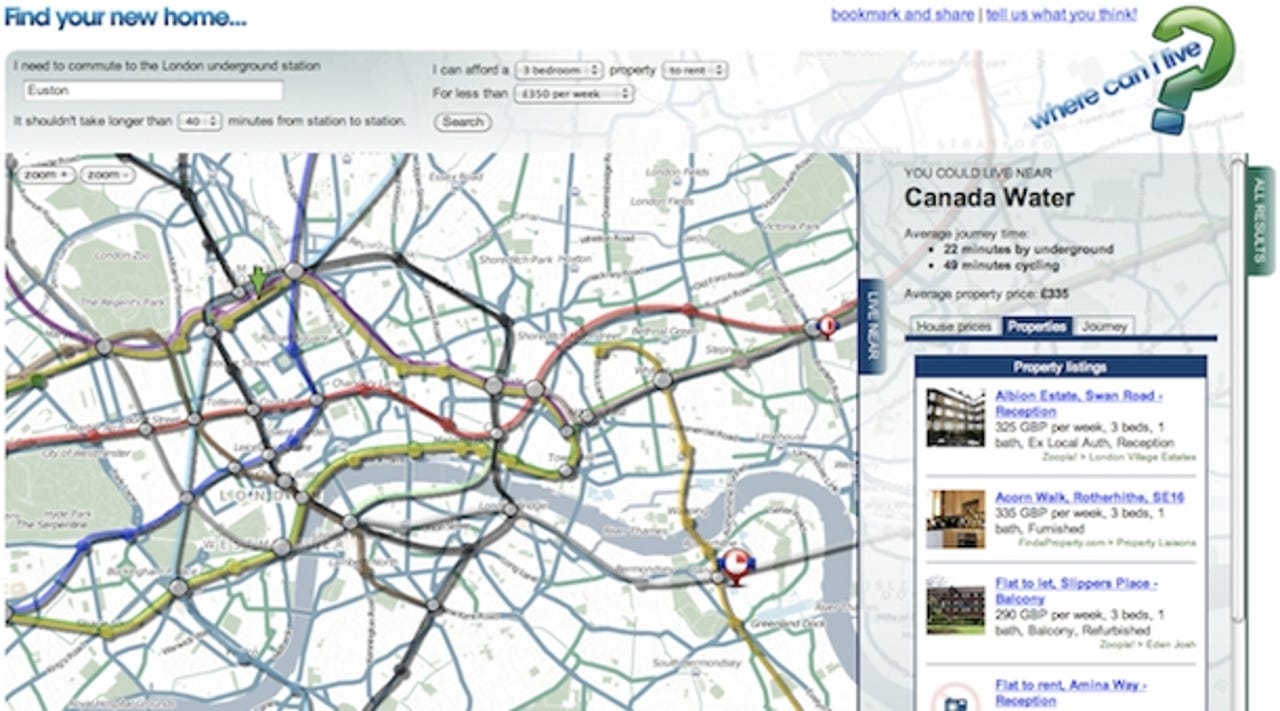
The Where Can I Live web app tells people where they can afford to live.
Users tell the app where they want to work, how expensive a house they can afford and how long a commute they will accept and the app will show them all the places where they could set up home.
The apps draws on information such as house prices and travel times, taken from a number of sources.
The FillThatHole web app provides an easy way for people to report potholes or other road hazards in an area.
Users simply mark the location of the pothole on the map and provide details of the nature of the pothole and the app will report it to the relevant highways authority asking them to fix it.
The app draws on Office for National Statistics census geography data.