Photos: Mars in full color

First color picture of Mars
This is the first color image of Mars from the High Resolution Imaging Science Experiment (HiRISE) camera on NASA's Mars Reconnaissance Orbiter, taken during a turn round the planet on March 24.
The HiRISE camera detects infrared radiation, which has a longer wavelength than visible light and so is not visible to the naked eye. The data has been converted to produce this image. It was generated by combining data from green and near-infrared color bandpass detectors on the camera with black-and-white images (from red-bandpass detectors). The image also has been processed to enhance subtle color variations.
The southern half of the scene is brighter and bluer than the northern half, perhaps due to early-morning fog in the atmosphere, NASA said. Large-scale streaks in the northern half are the result of wind on surface materials. The blankets of material ejected from the many small fresh craters are generally brighter and redder than the surrounding surface, but a few are darker and less red. In the bottom half of the image is a redder color in the rough areas, where wind and sublimation of water or carbon dioxide ice have partially eroded patches of smooth-textured deposits.
The Jet Propulsion Laboratory, a division of the California Institute of Technology in Pasadena, manages the Mars Reconnaissance Orbiter for NASA. The HiRISE camera was built by Ball Aerospace and Technology and is operated by the University of Arizona.
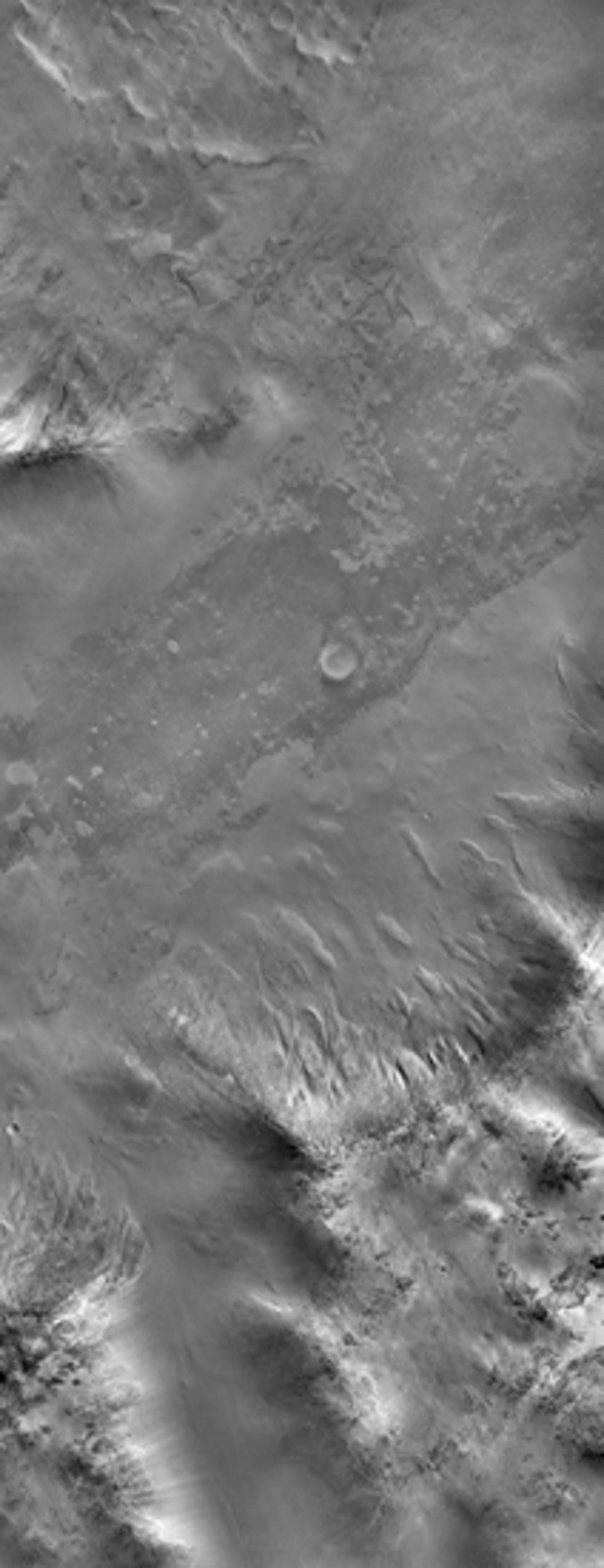
Mars in perspective
This perspective view gives an overview of the Mars terrain covered in the first color image from the HiRISE camera. The overview illustrates how the ridge has deformed several valleys and impact craters.
Argyre basin rim
This image shows part of a low mountain belt that rings the Argyre impact basin in Mars' southern hemisphere. The mountains or hills seen here are located in the northwestern part of the Charitum Montes.
Taken just minutes after the sun had risen over the horizon, only the sun-facing slopes are well-illuminated and much of the scene is in shadow, but the HiRISE camera has captured many details of the surface.
There are terrains that are both smooth and rough at this scale (9.65 feet per pixel). The rough terrain is littered with blocks roughly 30 feet across, and the smooth material has a uniform appearance broken by subtle, undulating ridges. The rough terrains are usually found at relatively high elevations, and smooth material occupies the lowest areas. In some locations it is evident that boulders from the rough terrain have tumbled downhill onto the smooth material. The smooth material is younger than the rough terrain, and some of it may have formed when water-rich or ice-rich debris flooded low-lying areas.
In other areas, the smooth material mantles the topography like deposits of airborne dust. Further upslope, the mountain flanks have a variety of rough textures. In places, the terrain has been eroded into streamlined forms and striations, suggestive of glacial erosion. Gullies formed in one spot near bottom center.
Perhaps the most striking aspect of this image is the dearth of fresh impact craters. The Argyre basin is thought to be billions of years old, but much more recent processes have greatly modified the surface.