Deserts, ravines, ancient ruins: How Google's Street View is scrambling along in Indiana Jones' footsteps

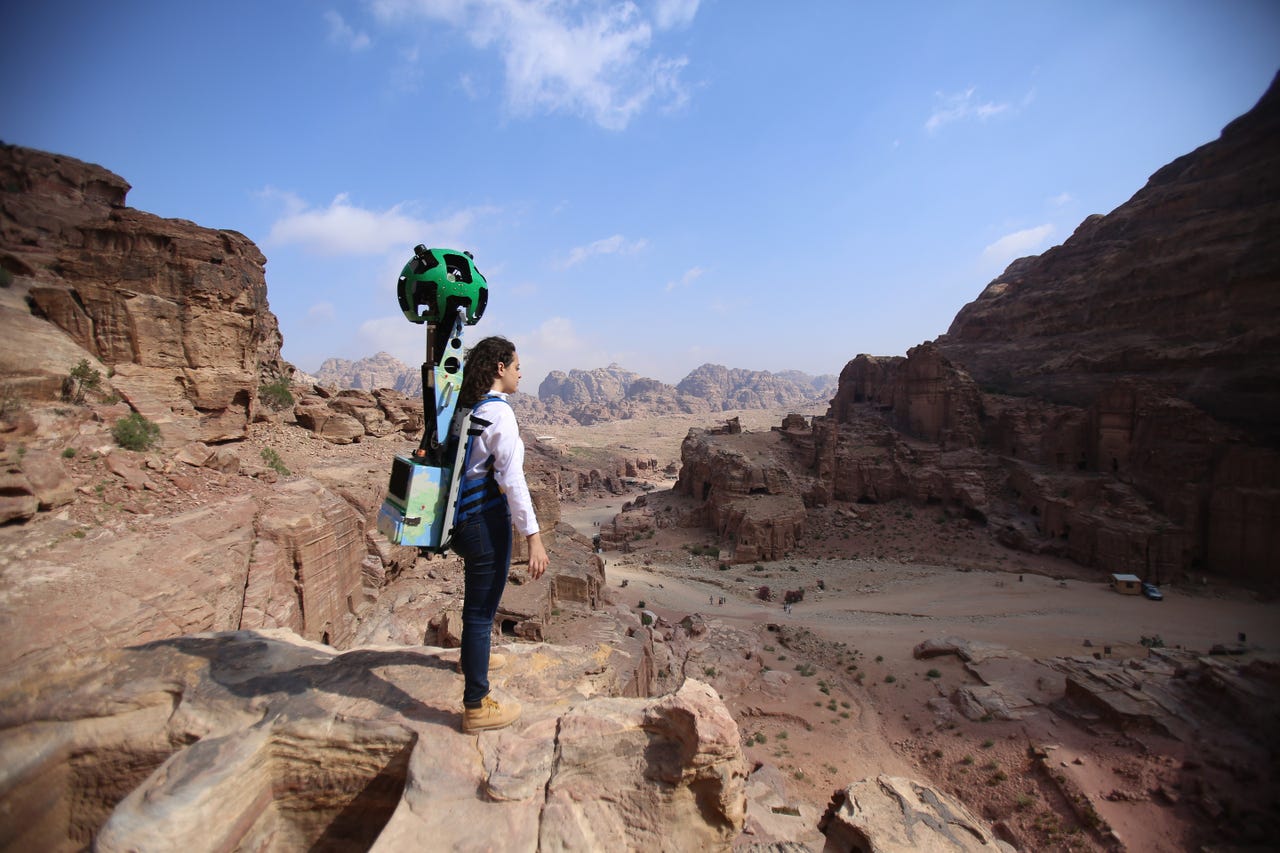
Google's Trekker system captures the images that allow Street View users to wander along footpaths, up hills, and down narrow gullies.
Launched just over a decade ago in February 2005, Google Maps now has over one billion monthly active users, with the service covering more than 200 countries and territories across the world, including, perhaps surprisingly, North Korea.
In the Middle East, where an absence of street names and signage poses a constant challenge for residents and businesses, the service has also grown rapidly.
There are now 14 localized Google maps, covering Saudi Arabia, UAE, Egypt, Bahrain, Iraq, Jordan, Kuwait, Lebanon, Morocco, Oman, Qatar, Tunisia, Yemen, and Algeria. The internet giant also provides a growing set of live traffic, direction, and navigation tools.
The importance of these types of services is particularly pertinent in the mobile age. Google told ZDNet that 30 percent of mobile search queries are related to location.
Alongside Google Earth, arguably Google's biggest innovation in the mapping space over the past decade has been Street View, its 360-degree imagery service. Since going live in 2007, Street View has captured the highways and byways of 75 countries around the world, while also going underwater and underground; scaling great heights; and visiting some of the world's oldest and most historic landmarks.
Across the Middle East, Street View activity has mostly fallen into the historic landmarks category. In 2014, Google launched special collections for the Pyramids of Giza and several of Egypt's other ancient sites such as the world's first pyramid at Djoser, the Hanging Church, and Cairo's medieval Citadel.
They have also provided users with insights into other parts of the region, ranging from the Liwa desert, one of the largest oases in the Arabian peninsula and home to Bedouin tribes, to modern architectural icons such as Abu Dhabi's spectacular Sheikh Zayed Grand Mosque and the world's tallest building, the Burj Khalifa.
However, in the past few months, this regional portfolio has been expanded. Last September, Google added full 360-degree street-level imagery from major streets in the Emirates of Sharjah and Ajman, adding the northern and least-populous Emirate of Umm Al Quwain in late March.
But perhaps the highest profile addition, at the end of November, was the creation of a special collection featuring images of Petra, the distinctive rose-red city used by Steven Spielberg in the film Indiana Jones and the Last Crusade, and 30 other notable landmarks across the Kingdom of Jordan.
For Ulf Spitzer, Google's global product lead for Street View, the launch represented "part of our ongoing effort to provide people with both a realistic and immersive experience of key historical sites around the world".
"With our Special Collects, we want to help preserve cultural heritage and let users take an in-depth look at specific historical sites," he tells ZDNet,
"Jordan is one of the most spectacular places that we've visited," he says. "We hope our imagery conveys all the grace, beauty, and deep heritage of the country."
Street View imagery is usually gathered by a camera mounted to the roof of a car, but on this occasion the team also used Google's Trekker system, a backpack that features a mounted camera.
By using this portable technology, the Google team were able to capture various perspectives from some of the places they visited, while also gaining access to locations that are often inaccessible to vehicles.
"In Sharjah, we used our Trekker to gather imagery of the scenic Al Majaz waterfront and the Al Qasba with its massive Eye of the Emirates ferris wheel," Spitzer explains.
These images have been supplemented by content captured by the Street View car. Imagery from Dubai, the first Arab city to have Street View on a street level back in 2014, was also updated at the same time. Things change quickly along the Sheikh Zayed road, the main artery into and around the city.
In contrast, many of the locations featured in Jordan, including Petra, the Dead Sea, the Roman ruins of Jerash, and important religious sites like the River Jordan and Mount Nebo, haven't changed in centuries.
Using data captured by Google's Trekker system, Street View users can wander down footpaths, up hills, and down narrow gullies, to experience a full 360-degree perspective of these historic locations.
In a blogpost announcing the launch of Google's Jordan collection, Her Majesty Queen Rania Al Abdullah of Jordan said: "That's one of the reasons I love this technology. Not only does it connect millions of people from all corners of the world, it provides a lens on the past. And when we understand more about each other's stories and cultures and histories, we realize that we are more alike than we are different."
Dubai Internet City
For the Kingdom of Jordan, Street View offers an opportunity to showcase many of the country's ancient wonders to potential visitors. But, as Google's Spitzer acknowledges, the technology can also be harnessed for a variety of different purposes.
"Street View as a feature of Google Maps has a variety of practical uses, for visitors, local businesses, residents, and students," he says. "For example, it can help tourists make better informed hotel bookings, or give a new restaurant a chance to showcase its location, which can help it connect with potential customers."
It also helps to shine a light on what Spitzer refers to as "complex regions" by "bringing their culture online, preserving it for their own people and, promoting it to the world".
"The region has a lot to offer and more and more people are coming online to know where to go and how to get there," he says.
Although some parts of the Middle East enjoy high levels of technology takeup, this digital enthusiasm often sits alongside deep-rooted anxieties about the cultural impact of technology and widespread privacy concerns.
These digital misgivings are, of course, not unique to the Arab world, and Google is at pains to point out that "Street View provides easily accessible tools for flagging inappropriate or sensitive imagery for review and removal".
"To safeguard privacy, we automatically blur faces and license plates that appear in Street View," Spitzer says.
"[We] also provide easy-to-use reporting tools so people can ask for images of their house, car, or themselves to be further obscured. The imagery you see is no different from what any person can readily capture or see walking down the street."
But nonetheless Google works with the authorities in each location around the globe to ensure Street View "abides by the local laws and has the support of our local partners".
Spitzer says Google will "continue to capture imagery in more cities throughout the Middle East and North Africa".
"There are thousands of years of history, architecture, and culture that these metropolises have to offer," he says.
Imagery of the 30 historical and other sites in Jordan is available on Google Maps and via g.co/Jordanhighlights and g.co/Petra.