Search
  • Videos
  • Windows 10
  • 5G
  • CES
  • Best VPNs
  • Cloud
  • Security
  • more
    • AI
    • TR Premium
    • Working from Home
    • Innovation
    • Best Web Hosting
    • ZDNet Recommends
    • Tonya Hall Show
    • Executive Guides
    • ZDNet Academy
    • See All Topics
    • White Papers
    • Downloads
    • Reviews
    • Galleries
    • Videos
    • TechRepublic Forums
  • Newsletters
  • All Writers
    • Preferences
    • Community
    • Newsletters
    • Log Out
  • Menu
    • Videos
    • Windows 10
    • 5G
    • CES
    • Best VPNs
    • Cloud
    • Security
    • AI
    • TR Premium
    • Working from Home
    • Innovation
    • Best Web Hosting
    • ZDNet Recommends
    • Tonya Hall Show
    • Executive Guides
    • ZDNet Academy
    • See All Topics
    • White Papers
    • Downloads
    • Reviews
    • Galleries
    • Videos
    • TechRepublic Forums
      • Preferences
      • Community
      • Newsletters
      • Log Out
  • us
    • Asia
    • Australia
    • Europe
    • India
    • United Kingdom
    • United States
    • ZDNet around the globe:
    • ZDNet France
    • ZDNet Germany
    • ZDNet Korea
    • ZDNet Japan

Gallery: Satellite images of killer cyclone

1 of 9 NEXT PREV
  • 200818.jpg

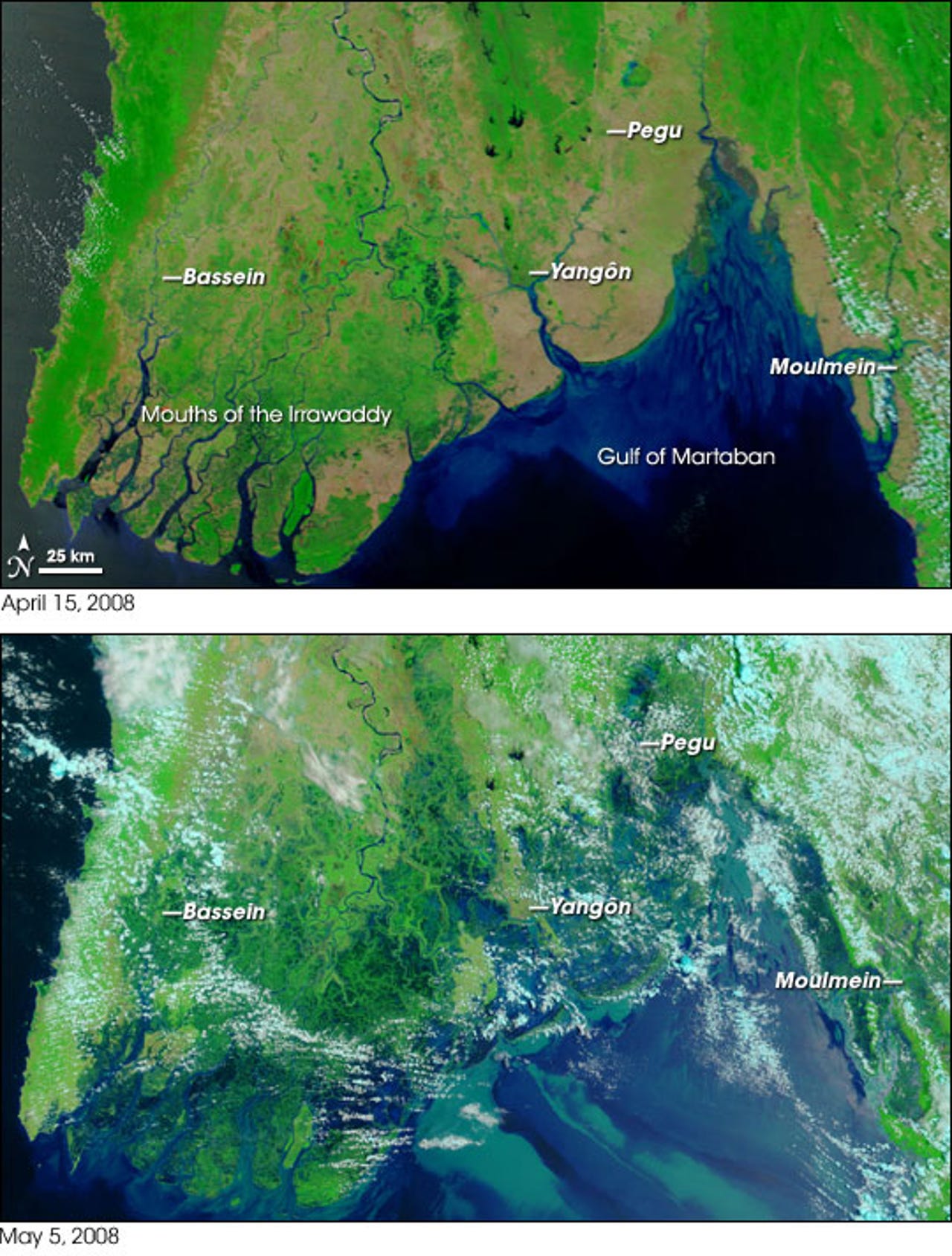
    The government of Myanmar (formerly known as Burma) has reported that over 22,000 people have died so far due to the effects of Tropical Cyclone Nargis which hit the country on May 3. But experts think the death tool is more likely between 63,000 and 100,000 people, according to CNN. Worldwide humanitarian efforts are being slowed down by an isolationist government which brings fears of even more mass deaths to follow because of disease and starvation.

    The image above shows Myanmar on April 17 before Cyclone Nargis hit while the image below shows the flooding of about 130,000 square miles in the Irriwadi Delta on May 5, after the storm.

    Photo credit: NASA/MODIS Rapid Response Team

    Published: May 9, 2008 -- 11:46 GMT (04:46 PDT)

    Caption by: Andy Smith

  • 200823.jpg

    The image above was taken on May 7 and shows the flooding as compared to the lower image taken on April 19 before Tropical Cylclone Nargis.

    Photo credit: NASA/MODIS Rapid Response Team

    Published: May 9, 2008 -- 11:46 GMT (04:46 PDT)

    Caption by: Andy Smith

  • 200819.jpg

    On May 3, 2008, Tropical Cylclone Nargis was directly over Myanmar

    Published: May 9, 2008 -- 11:46 GMT (04:46 PDT)

    Caption by: Andy Smith

  • 200820.jpg

    The coastal region in Myanmar along the Bay of Bengal is heavily populated and prone to flooding. This image shows the rainfall accumulations along the path of Cyclone Nargis with the heaviest areas in blue. Almost two feet of rain was recorded in the dark blue patches.

    The storm was a measured as a Category 2 cyclone over the Bay of Bengal, then diminished to Category 1 storm before gaining steam to Category 3 strength with sustained winds of 120mph when it hit land.

    Credit: NASA/Jesse Allen, using data provided by the TRMM science team
    Published: May 9, 2008 -- 11:46 GMT (04:46 PDT)

    Caption by: Andy Smith

  • 200821.jpg

    This image from April 28 shows the storm as it was still forming--right after it officially became a Category 1 clone with sustained winds of 75mph.

    Credit: NASA

    Published: May 9, 2008 -- 11:46 GMT (04:46 PDT)

    Caption by: Andy Smith

  • 200822.jpg

    This image from NASA's Aqua satellite shows the temperature of the cloud tops with orange the warmest and purple the lowest. The high high, cold cloud tops (purple) show the center of the storm.

    Credit: NASA/JPL

    Published: May 9, 2008 -- 11:46 GMT (04:46 PDT)

    Caption by: Andy Smith

  • 200824.jpg

    This 3D image of Cyclone Nargis shows the height of the clouds as it rolled over Myanmar. The tallest clouds (red) are areas of severe thunderstorms that are associated with the intense rainfall.

    Image: Hal Pierce (SSAI/NASA GSFC)

    Published: May 9, 2008 -- 11:46 GMT (04:46 PDT)

    Caption by: Andy Smith

  • 200825.jpg

    This map shows the amount of precipitation over Myanmar on May 3 as Cylclone Nargis passed over.

    Credit: Hal Pierce, SSAI/NASA GSFC

    Published: May 9, 2008 -- 11:46 GMT (04:46 PDT)

    Caption by: Andy Smith

  • 200880.jpg

    Hurricane Katrina, as seen on this August 29, 2005 was a Category 4 hurricane with sustained winds of 145 mph when it hit the U.S. coast.

    Hurricanes and cyclones are basically the same type of storms that contain sustained winds of more than 74mph. They are called hurricanes over the Atlantic, the Northeast Pacific east of the International Dateline, or the South Pacific Ocean; and cyclones over the Indian Ocean.

    Published: May 9, 2008 -- 11:46 GMT (04:46 PDT)

    Caption by: Andy Smith

1 of 9 NEXT PREV
Andy Smith

By Andy Smith | May 9, 2008 -- 11:46 GMT (04:46 PDT) | Topic: Networking

  • 200818.jpg
  • 200823.jpg
  • 200819.jpg
  • 200820.jpg
  • 200821.jpg
  • 200822.jpg
  • 200824.jpg
  • 200825.jpg
  • 200880.jpg

Satellite images from NASA show the track of a cyclone and the resulting flooding that may end up killing over 100,000 residents of Myanmar (formerly Burma).

Read More Read Less

The government of Myanmar (formerly known as Burma) has reported that over 22,000 people have died so far due to the effects of Tropical Cyclone Nargis which hit the country on May 3. But experts think the death tool is more likely between 63,000 and 100,000 people, according to CNN. Worldwide humanitarian efforts are being slowed down by an isolationist government which brings fears of even more mass deaths to follow because of disease and starvation.

The image above shows Myanmar on April 17 before Cyclone Nargis hit while the image below shows the flooding of about 130,000 square miles in the Irriwadi Delta on May 5, after the storm.

Photo credit: NASA/MODIS Rapid Response Team

Published: May 9, 2008 -- 11:46 GMT (04:46 PDT)

Caption by: Andy Smith

1 of 9 NEXT PREV

Related Topics:

Networking Cloud Internet of Things Security Data Centers
Andy Smith

By Andy Smith | May 9, 2008 -- 11:46 GMT (04:46 PDT) | Topic: Networking

Show Comments
LOG IN TO COMMENT
  • My Profile
  • Log Out
| Community Guidelines

Join Discussion

Add Your Comment
Add Your Comment

Related Galleries

  • 1 of 3
  • TRENDnet TUC-ET5G USB-C 3.1 to 5GBASE-T Ethernet adapter

    The TRENDnet TUC-ET5G USB-C 3.1 to 5GBASE-T Ethernet adapter is capable of some serious data throughput -- up to 5Gbps over existing Cat5e or better cabling. ...

  • Anker PowerExpand 8-in-1 USB-C hub

    If you need a portable USB-C hub with an Ethernet port, this is for you.

  • Netgear Orbi RBK752 tri-band Gigabit Wi-Fi 6 mesh

    Netgear expands its Gigabit Wi-Fi 6 offering with a new, lower-priced, Orbi RBK752 mesh system.

  • Plugable UD-CA1A USB-C dock

    Universal USB 3.1 Type-C docking station with Power Delivery. 4K-capable HDMI display (4K at 30Hz, 2560x1600 at 60Hz). Provides 60W of power to charge attached system ...

  • OWC Thunderbolt 3 10G Ethernet Adapter

    The OWC Thunderbolt 3 10G Ethernet Adapter capable of connecting to hyper-fast networks and offers amazing output speeds up to 10GBASE-T.

  • Plugable super-fast 2.5Gbps Ethernet adapter (in pictures)

    Need to connect your new laptop to a wired Ethernet network? Plugable has released a new 2.5Gbps Ethernet adapter, compatible with USB-C and USB 3.2 Gen 1. ...

  • Synology DS218j - Unboxing and fitting hard drives

    Adding many terabytes of storage to a network.

ZDNet
Connect with us

© 2021 ZDNET, A RED VENTURES COMPANY. ALL RIGHTS RESERVED. Privacy Policy | Cookie Settings | Advertise | Terms of Use

  • Topics
  • Galleries
  • Videos
  • Sponsored Narratives
  • Do Not Sell My Information
  • About ZDNet
  • Meet The Team
  • All Authors
  • RSS Feeds
  • Site Map
  • Reprint Policy
  • Manage | Log Out
  • Join | Log In
  • Membership
  • Newsletters
  • Site Assistance
  • ZDNet Academy
  • TechRepublic Forums