This NASA image from August 24 clearly shows the eye of Hurricane Irene.
Hurricane Irene images as it nears the East Coast
UPDATE: Residents of the East Coast could very well experience an earthquake and a hurricane within a week.

1 of 17 Andy Smith/ZDNET
UPDATE:Thursday Aug. 26, 11 AM PT: The U.S. National Hurricane Center has some good news as winds created by Hurricane Irene have dropped to an average of 100mph with gusts up to 155mph. The hurricane has dropped to a Category 2 hurricane as it is expected to hit or pass near the North Carolina Coast on Saturday. It's located about 300 miles from Cape Hatteras North Carolina and moving at 14mph. It is expected to turn north or northeast Saturday. Category 5 is the most severe. (Katrina averaged winds of 175mph over the Gulf of Mexico and reportedly 125mph when it hit land).
One of the real dangers of hurricanes is the raise in the water level. The water level along the North Carolina coast is expected to raise between 6 and 11 feet.
In this gallery, we'll take a look at how Hurricane Irene looks from space, on maps, and on land, too.
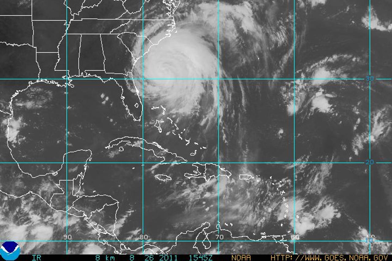
This is an infrared image of Hurricane Irene taken by the GOES satellite.
Credit: NOAA
This post was originally published on Smartplanet.com
2 of 17 Andy Smith/ZDNET
This 3-day track from August 26 shows the hurricane will likely head up the East Coast before going ashore in Connecticut.
A hurricane warning is in effect for Little River Inlet North Carolina northward to Sandy Hook, New Jersey inluding Pamlico, Albemarle and Currituck Sounds, Deleware Bay, and Chesapeake Bay south of Drum Point.
This post was originally published on Smartplanet.com3 of 17 Andy Smith/ZDNET
The 5-day cone shows Hurricane Irene heading back to the Canadian coast after walloping New England.
This post was originally published on Smartplanet.com4 of 17 Andy Smith/ZDNET
Here's where to hurricane force winds are striking today.
This post was originally published on Smartplanet.com5 of 17 Andy Smith/ZDNET
This NASA photo taken on Aug. 25 shows the clouds from Hurricane Irene take up 1/3 of the U.S. East Coast.
This post was originally published on Smartplanet.com6 of 17 Andy Smith/ZDNET
This water vapor map from August 26 shows the extensive rainfall outlining the hurricane.
This post was originally published on Smartplanet.com7 of 17 Andy Smith/ZDNET
This post was originally published on Smartplanet.com
8 of 17 Andy Smith/ZDNET
Officials in Nags Head, N.C. are putting up "No Swimming" flags. It may seem like a no brainer...
Credit: CBS News
This post was originally published on Smartplanet.com9 of 17 Andy Smith/ZDNET
...but there are always some idiots who think they can play in a major storm.
Credit: CBS News
This post was originally published on Smartplanet.com10 of 17 Andy Smith/ZDNET
It's "Mandatory Evacuation" for residents of Nags Head, N.C.
This post was originally published on Smartplanet.com11 of 17 Andy Smith/ZDNET
Here's a view from the International Space Station.
Credit: NASA
This post was originally published on Smartplanet.com12 of 17 Andy Smith/ZDNET
This image from the TRMM satellite on Aug. 23 shows the rain and clouds from Hurricane Irene. Areas in red mark the tops of deep convection towers near the center and in the outer rainbands with tops near 9 miles high (brighter red areas). Also, evident at this time is an area of shallow tops (in blue) near to the center where the drier air had worked its way into the storm.
Credit: SSAI/NASA, Hal Pierce
This post was originally published on Smartplanet.com13 of 17 Andy Smith/ZDNET
This infrared image from the AIRS instrument on NASA's Aqua satellite shows Hurricane Irene right off the Florida, Georgia and South Carolina coasts on Aug. 26. There is a very large area of strong thunderstorms around the center of circulation and also in a large band of on the northeastern quadrant that appear in purple.
Credit: NASA/JPL, Ed Olsen
This post was originally published on Smartplanet.com14 of 17 Andy Smith/ZDNET
Predicted oceanic conditions in the Atlantic are ripe for hurricane formation from August-October this year.
Credit: National Hurricane Center
This post was originally published on Smartplanet.com15 of 17 Andy Smith/ZDNET
Here are the predicted sea surface temperatures from August-October which are expected to be higher than normal - creating favorable conditions for hurricanes.
This post was originally published on Smartplanet.com16 of 17 Andy Smith/ZDNET
Wetter conditions than normal from West African monsoons, coupled with suppressed convection over the Amazon Basin has led to higher ocean temperatures and an increased likelihood of hurricanes.
This post was originally published on Smartplanet.com17 of 17 Andy Smith/ZDNET
This map shows the sea surface temperatures which are above average this year - in fact the third highest since 1981 when records were first kept.. One requirement of a hurricane is that ocean temperatures exceed 26.5°C (79.7°F) and generally when storms will intensify when they hit warmer water and recede when the water gets cooler.
This post was originally published on Smartplanet.comRelated Galleries
Holiday wallpaper for your phone: Christmas, Hanukkah, New Year's, and winter scenes
![Holiday lights in Central Park background]()
Related Galleries
Holiday wallpaper for your phone: Christmas, Hanukkah, New Year's, and winter scenes
21 Photos
Winter backgrounds for your next virtual meeting
![Wooden lodge in pine forest with heavy snow reflection on Lake O'hara at Yoho national park]()
Related Galleries
Winter backgrounds for your next virtual meeting
21 Photos
Holiday backgrounds for Zoom: Christmas cheer, New Year's Eve, Hanukkah and winter scenes
![3D Rendering Christmas interior]()
Related Galleries
Holiday backgrounds for Zoom: Christmas cheer, New Year's Eve, Hanukkah and winter scenes
21 Photos
Hyundai Ioniq 5 and Kia EV6: Electric vehicle extravaganza
![img-8825]()
Related Galleries
Hyundai Ioniq 5 and Kia EV6: Electric vehicle extravaganza
26 Photos
A weekend with Google's Chrome OS Flex
![img-9792-2]()
Related Galleries
A weekend with Google's Chrome OS Flex
22 Photos
Cybersecurity flaws, customer experiences, smartphone losses, and more: ZDNet's research roundup
![shutterstock-1024665187.jpg]()
Related Galleries
Cybersecurity flaws, customer experiences, smartphone losses, and more: ZDNet's research roundup
8 Photos
Inside a fake $20 '16TB external M.2 SSD'
![Full of promises!]()